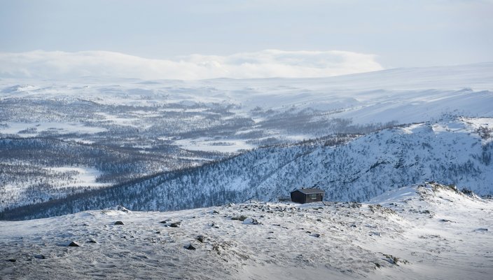
A mountain village at 988 meters on Hardangervidda plateau, serving as the starting point for the Rallarvegen cycling trail and winter snowkiting.
Haugastøl sits at 988 meters on Norway's Hardangervidda plateau, directly between Oslo and Bergen. You arrive here by train on the Oslo-Bergen line or via mountain roads winding through dramatic landscapes. This village is the gateway to Hardangervidda and Hallingskarvet National Parks. The historic Rallarvegen bike trail starts here. In summer, cyclists ride rugged routes toward Finse and hikers explore glacier-carved valleys. Winter turns the plateau into a large snowkiting area where steady winds sweep across frozen lakes.
Travel to Haugastøl
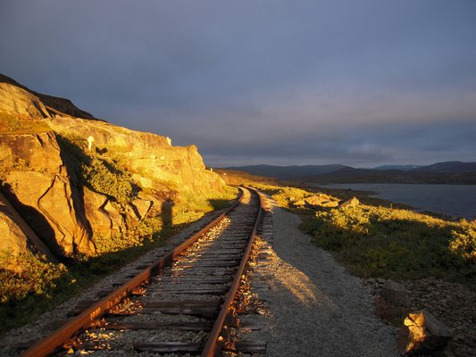
Take the direct train from Oslo or Bergen on the Oslo-Bergen railway, run by Vy Tog. Book tickets early online for lower fares. Trains include wheelchair-accessible carriages; reserve assistance ahead for smooth boarding. If you drive, the mountain road from Bergen takes about 3.5 hours, including a short ferry trip. From Oslo, allow 4.5 hours. Winter travel requires careful preparation: use studded winter tires, pack extra fuel, warm clothing, food, and water. Roads can close suddenly during storms. Check conditions using Norway’s road authority hotline (175) before you leave.
Things to Do in Haugastøl by Season
Summer focuses on cycling the Rallarvegen trail. This 27-kilometer gravel path follows the railway to Finse through raw mountain terrain. Rent bikes at Haugastøl Turistcenter. Try sections like the ride to Oksebotn Vokterbolig, an 18th-century navvy cabin. Hikers walk trails through Krækkja to Fagerheim or climb Hallingskarvet’s ridges for wide views. In winter, cross-country skiing routes spread across the plateau. Snowkiting is popular; kite schools operate near the Turistcenter, using Hardangervidda’s large, wind-consistent snowfields. Always respect reindeer conservation zones; temporary closures protect herds during harsh months.
Services at Haugastøl Turistcenter
This family-run hub has all essentials: rooms, meals, bike rentals, and kite equipment. It’s the only place in Haugastøl for food, shelter, or gear. The restaurant cooks local dishes. Staff arrange shuttles to Ustaoset station 12 kilometers away if you need it. In winter, they coordinate snowmobile transport to good kiting spots when roads are blocked. Weather stations stream real-time wind and visibility data online, helping you plan adventures.
Natural Places Near Haugastøl
Hardangervidda National Park starts at Haugastøl’s edge. Trails cross Europe’s largest high-altitude plateau. You might see arctic foxes or reindeer while hiking to glacial lakes like Skaupsjøen. Neighboring Hallingskarvet National Park has steeper climbs along its mountain range. The summit hike gives fjord views on clear days. Cyclists can detour to Vøringsfossen waterfall, 40 minutes by car, where water drops 182 meters into Måbødalen valley. Winter visitors reach frozen areas good for snowkiting, with open ground stretching toward the Hardangerjøkulen glacier.
Planning Your Haugastøl Visit
Haugastøl Station and the Turistcenter are 1 kilometer apart; walk or bike between them. Summer temperatures average 10–15°C; bring waterproof layers and sturdy boots. Winter temperatures fall below freezing with heavy snow; insulated gear and windproof jackets are necessary. Snowkite season runs October to June. The best conditions are January–March for powder or March–May for longer daylight. Helicopter transfers land near the Turistcenter for direct access from major airports. Check train schedules on Vy’s website. Confirm road openings during winter storms.